136199 Eris will reach opposition – the optimal time to observe it, when it will be visible for much of the night in the constellation Cetus.
From South El Monte, it will be visible between 20:40 and 05:02. It will become accessible at around 20:40, when it rises to an altitude of 21° above your eastern horizon. It will reach its highest point in the sky at 00:51, 55° above your southern horizon. It will become inaccessible at around 05:02 when it sinks below 21° above your western horizon.
A close approach to the Earth

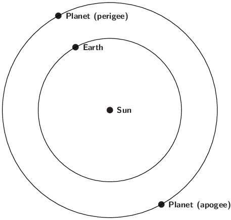
When a planet is at opposition, the solar system is aligned with that planet on the same side of the Sun as the Earth.
The term opposition refers to the moment when a planet passes opposite to the Sun in the sky. For those planets which orbit the Sun at a greater distance than the Earth – like 136199 Eris – this geometry occurs as the two planets pass each other in their orbits and they make closest approach – termed its perigee.
At opposition / perigee, planets are visible for much of the night, reaching their highest point in the sky around midnight local time, just as the Sun, 180° away, dips to its lowest point below the horizon.
Because it passes closest to the Earth at this time, the planet also appears at its brightest around opposition.
In practice, the variation for 136199 Eris is quite modest since it orbits much further out in the solar system than the Earth – at an average distance from the Sun of 68.00 times that of the Earth. Consequently, its distance and brightness does not vary much as it cycles between opposition and solar conjunction. The variation is much greater for Mars, since it lies much closer to the Earth.
Observing 136199 Eris
At opposition, 136199 Eris is visible for much of the night. Even when it is at its closest point to the Earth, however, 136199 Eris is so distant from the Earth that it is not possible to distinguish it as more than a star-like point of light, even through a telescope.
A chart of the path of 136199 Eris across the sky in 2025 can be found here, and a chart of its rising and setting times here.
At the moment of opposition, 136199 Eris will lie at a distance of 94.57 AU, and reach a peak brightness of magnitude 18.6. At opposition, its celestial coordinates will be:
| Object | Right Ascension | Declination | Constellation | Magnitude | Angular Size |
| 136199 Eris | 01h47m30s | 0°22'S | Cetus | 18.6 | 0.0" |
The coordinates above are given in J2000.0.
Over the weeks following its opposition, 136199 Eris will reach its highest point in the sky around four minutes earlier each night, gradually receding from the pre-dawn morning sky while remaining visible in the evening sky for a few months.
The sky on 18 Oct 2025
| The sky on 18 October 2025 | ||||||||||||||||||||||||||||||||||
|
7% 26 days old |
All times shown in PDT.
|
|||||||||||||||||||||||||||||||||
Source
The circumstances of this event were computed using the DE430 planetary ephemeris published by the Jet Propulsion Laboratory (JPL).
This event was automatically generated by searching the ephemeris for planetary alignments which are of interest to amateur astronomers, and the text above was generated based on an estimate of your location.
Related news
| 18 Oct 2025 | – 136199 Eris at opposition |
| 18 Oct 2026 | – 136199 Eris at opposition |
| 18 Oct 2027 | – 136199 Eris at opposition |
| 18 Oct 2028 | – 136199 Eris at opposition |
Image credit
© NASA/Hubble Space Telescope


